File:USMC Barracks Lebanon 1983 Map.jpg
From Self-sufficiency
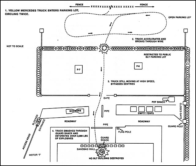
Revision as of 11:50, 12 June 2010 by Jontas (Talk | contribs) (Source: http://ibiblio.net/hyperwar/AMH/XX/MidEast/Lebanon-1982-1984/USMC-Lebanon82/USMC-Lebanon82-1.html Sketch map of the route taken by the terrorist bomber on the morning of 23 October 1983. [From the Long Commission Report]. {{PD-USGov-Military}} )
USMC_Barracks_Lebanon_1983_Map.jpg (640 × 542 pixels, file size: 63 KB, MIME type: image/jpeg)
Source: http://ibiblio.net/hyperwar/AMH/XX/MidEast/Lebanon-1982-1984/USMC-Lebanon82/USMC-Lebanon82-1.html
Sketch map of the route taken by the terrorist bomber on the morning of 23 October 1983. [From the Long Commission Report].
| |
This image is a work of a U.S. military or Department of Defense employee, taken or made during the course of an employee's official duties. As a work of the U.S. federal government, the image is in the public domain. See http://www.defenselink.mil/multimedia/about.html. català | čeština | English | eesti | suomi | français | italiano | 日本語 | 한국어 | português | română | slovenčina | ไทย | Tiếng Việt | +/− |
 |
File history
Click on a date/time to view the file as it appeared at that time.
| Date/Time | Thumbnail | Dimensions | User | Comment | |
|---|---|---|---|---|---|
| current | 11:50, 12 June 2010 |  | 640 × 542 (63 KB) | Jontas (Talk | contribs) | Source: http://ibiblio.net/hyperwar/AMH/XX/MidEast/Lebanon-1982-1984/USMC-Lebanon82/USMC-Lebanon82-1.html Sketch map of the route taken by the terrorist bomber on the morning of 23 October 1983. [From the Long Commission Report]. {{PD-USGov-Military}} |
- You cannot overwrite this file.
File usage
The following page links to this file:
